

In this section:
- What is an ecologically or biologically significant area?
- How does the EBSA process work?
- What is GOBI’s role in the EBSA process?
- Where next for EBSAs?
- How can EBSAs be used in conservation planning?
What is an ecologically or biologically significant area (EBSA)?
An EBSA is an area of the ocean that has special importance in terms of its ecological and biological characteristics: for example, by providing essential habitats, food sources or breeding grounds for particular species. In 2008, a process to recognise these special areas was put in place by the United Nations Convention on Biological Diversity (CBD). Based on a set of seven scientific criteria, this process provides a framework to methodically and objectively describe those areas of the ocean that are crucial to the healthy functioning of the global marine ecosystem. EBSAs are areas of the ocean that are judged – through a technical process – to meet one or more of the following seven scientific criteria:
- Uniqueness or rarity
- Special importance for life history stages of species
- Importance for threatened, endangered or declining species and/or habitats
- Vulnerability, fragility, sensitivity, or slow recovery
- Biological productivity
- Biological diversity
- Naturalness
EBSAs cover many different types of marine ecosystems in different regions: they encompass areas that have been shown to hold the greatest richness of species and productivity, possess rare or endemic species, or are home to unique communities of fauna and flora.
To date, there are more than 321 EBSAs described around the world. They occur in all regions of the planet from the poles to the equator, and in all water depths from the coast to the deep ocean. They can be found in national waters, span territorial boundaries, lie partially or wholly within areas beyond national jurisdiction, and can even overlap each other. There is no minimum or maximum size for an EBSA, they can be small or cover vast expanses of the ocean.
The flexibility of the EBSA approach reflects the dynamic and complex nature of the marine environment. For example, an EBSA can be based around a single static feature, such as a seamount, or a collection of similar features, such as a chain of seamounts, where interconnectivity between the individual seamounts is critical for the overall health and survival of the local ecosystem. EBSAs may also contain a variety of seafloor features over a range of water depths that collectively provide important habitat for marine communities.
If appropriate, EBSAs can move position over time, and their boundaries can change dynamically in line with seasonal, annual or longer-term shifts in oceanographic or climatic features, such as seasonal changes in ocean circulation or patterns of sea ice. This allows the EBSA description to reflect more accurately the natural variability of its ecological or biological characteristics.
The EBSA designation does not bring any management measures or restriction of activities – it is simply recognition of an area’s biological or ecological significance. However, the information used to describe EBSAs can also be highly valuable for conservation and management, for example in supporting the case for area-based management tools, such as marine protected areas or environmental impact assessments.

How does the EBSA process work?
Since 2012, a series of regional workshops has been convened around the world by the CBD to examine the information available to support the description of EBSAs. Scientific, regional and technical experts come together to source, discuss and assess the data available for a particular region of the ocean.
Describing EBSAs is a technical exercise, but as well as scientific data, other sources of information are taken into account, such as traditional knowledge which encompasses the knowledge, innovations and practices of indigenous peoples and local communities. The results are a series of technical descriptions of areas of the ocean that are considered important in the context of one or more of the seven scientific EBSA criteria. EBSA descriptions are assessed by the CBD’s Subsidiary Body on Scientific, Technical and Technological Affairs (SBSTTA) and subsequently considered at the CBD’s Conference of the Parties.
As of September 2019, 15 workshops have taken place in the following regions, collectively covering almost 76% of the world’s ocean:
- Western South Pacific Ocean
- Wider Caribbean & Western Mid-Atlantic Ocean
- Southern Indian Ocean
- Eastern Tropical & Temperate Pacific Ocean
- North Pacific Ocean
- South-Eastern Atlantic Ocean
- Arctic Ocean
- North-West Atlantic Ocean
- Mediterranean Sea
- North-East Indian Ocean
- North-West Indian Ocean and adjacent Gulf areas
- Seas of East Asia
- Black Sea and Caspian Sea
- Baltic Sea
- North-East Atlantic Ocean
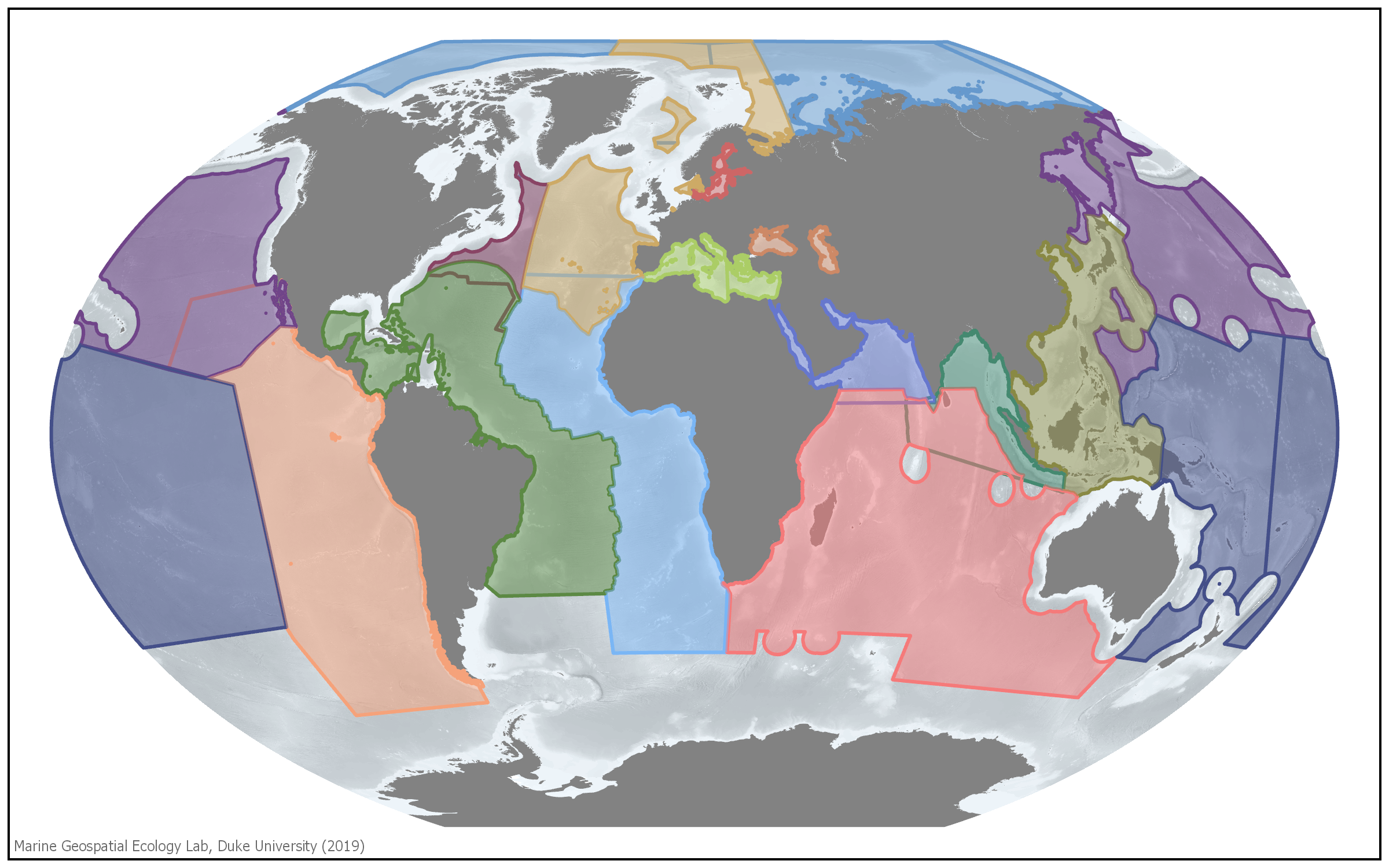
To date, these workshops have generated 321 recognised EBSAs around the world (candidate EBSAs described in the most recent EBSA regional workshop in the North-East Atlantic Ocean have yet to be adopted by CBD COP). EBSA descriptions are kept in the CBD’s EBSA Repository, and are available online along with the official reports of the regional workshops.
What is GOBI’s role in the EBSA process?
GOBI partners provide strategic input into each stage of the EBSA process. GOBI has been represented in all EBSA regional workshops, providing scientific expertise, guidance and consistency in the application of EBSA criteria across areas, workshops and regions. GOBI partners CSIRO and the Marine Geospatial Ecology Lab (MGEL) at Duke University provide specific expert technical support for data collation and visualisation.
A review of the decade-old the EBSA process, compiled and co-authored by GOBI Secretariat and selected partners was launched in 2021.
GOBI partners also provide EBSA-related training and capacity building via the CBD’s Sustainable Ocean Initiative, which in 2021 celebrated its tenth anniversary by launching a review of progress made during its first decade.
Where next for EBSAs?
The EBSA process is evolving. There is a renewed drive to update and strengthen the evidence base in support of existing EBSAs, as well as continuing to describe additional EBSAs during future workshops. Parties are also invited to include the results of their national EBSA-like processes in the EBSA Repository. In addition, EBSAs are to be assessed against four emerging categories: static, dynamic, grouped or ephemeral. Future consideration is to be given to the assessment of gaps in the representativity of EBSAs, especially in areas beyond national jurisdiction. The aim is to provide relevant ecological or biological information to support States and competent international organisations who can take management measures including the design and establishment of a coherent, representative network of marine protected areas that will help implement an ecosystem-based approach to environmental conservation and management.
How can EBSAs be used in conservation planning?
Some Parties to the CBD have already used EBSA descriptions to inform their national processes or to secure international funding to support further research. Competent authorities have also begun to incorporate information from the EBSA process into their management decisions. It is anticipated that EBSAs will play an important role in the discussions surrounding the development of a new international legally binding instrument under UNCLOS to support the conservation and sustainable use of marine biological diversity beyond areas of national jurisdiction.
The EBSA process provides a recognition of special marine areas based on the consistent application of internationally agreed scientific criteria. This information can be used to support area-based planning and decision making. Five examples of conservation management practices that have incorporated EBSAs and EBSA-like processes into decision-making are:
- In the Atlantic, research has sought to integrate EBSAs, Vulnerable Marine Ecosystems (VMEs) and High Seas MPAs with ‘Blue Growth’ scenarios. This research was undertaken by the EU ATLAS Project, with 12 case studies intended to demonstrate options for integration at an appropriate scale.
- Portugal is proposing the establishment of large national EBSAs on its extended continental shelf. These proposals have to be consistent with national marine spatial planning objectives and the development of indicators to ensure conservation and delivery against targets and measures set out by the EU Marine Strategy Framework Directive.
- In Mauritanian waters, EBSA data are being used to support the case at the International Maritime Organization to create a Particularly Sensitive Sea Area on the basis that biodiversity in that area is vulnerable to impacts from international shipping.
- In South Africa, a national process ‘Operation Phakisa’ has used EBSA data to contribute to baseline information as part of a holistic planning exercise resulting in conservation measures.
- The North-western Mediterranean Pelagic Ecosystems EBSA illustrates how EBSA criteria can underpin advocacy for detailed management options (further research, fisheries gear specifications, seasonal closures, MPAs).